
Lake Mapping – An option for cheap electronics for finding fish – Navionics on a cell phone
Lake Mapping – An option for cheap electronics for finding fish – Navionics on a cell phone
 Navionics mapping, lake maps, finding fish using a cell phone is a quick option for cheap electronics for your boat, or even shore fishing.
Finding fish can be difficult without some tools. In this video I show how you can use your cell phone to find the fish you’re looking for.
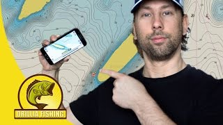
Navionics has been my go-to for a few years now. I first got the demo app and fell in love right away. This app is available on your PC under the WebApp link below.
The app is a paid app, after the demo version is done. It runs for a little over $15 for the year and it’s well worth that money! The app allows you to put markers on the map for places you like to fish, or want to fish. It also lets you record your boating tracks so you can revisit your milk runs.
Although maps will get you on the spot and maybe find a few spots you didn’t know existed, you’ll probably want to still invest in a cheap sonar unit. It’s nice to know where the weed lines start and end, boulders that stick out from the bottom, or any other features you can’t see from a map alone.
Links:
Navionics WebApp: webapp.navionics.com/#boating
Social Media:
Instagram- orilliafishing
Facebook: https://www.facebook.com/orilliafishing/
Website: http://www.orilliafishing.com
Sponsors:
Ardent: https://ardentoutdoors.com/


Right on brother! Navionics is the way to go. Stumbled on it before my Indiana Muskie trip a month ago. Raised over 34 Muskie caught 3 and lost 6 boatside. The app allowed me to return to the spot where fish was. Nice tutorial 🎣
Try gofreemaps. It is a site that uses sonar that is submitted by users. They say $100 a year but it has always been free so far. Good for lowrance, somrad and B&G units. And you can map your own lakes like I did. Very cool to make your own maps. BTW cool to see a cdn channel.
Awesome video! I got this app around 6 months ago and it’s been worth way more than the $9.99 I got it for. I liked and subbed. Keep up the good work and tips. Check out my channel if you get a minute. Thanks!
Nice sir
This is only good if you have cel service? correct?
I use the Navionics on my phone as well. Great app for a great price. I use it for both land and water. Thanks for the vid.
So if I have a plotter I can upload this app as my preferred plotting app as well? Or would that not make sense, would the plotter be more comprehensive? Thanks for the video
Great video! I just downloaded the app as it was a a gift from my Daughter. We fish the same places Brother. I fished Dalrymple for 26 years!
Are you able to see the navioincs app on fish finders ?
Sweet vid man
Does it record and save GPS coordinates?
I think you did a great job explaining the basics and some of the functions you like about navionics app. Helpful.
When downloading this app, it requires permission to manage your phone calls. Why would it need that to operate? From the research I’ve done and read, it could literally makes calls to "900" numbers charging it to your phone. As well as posting any pics you have on the phone to the internet without your knowledge. Anyone experience these types of activities with this app?
hey man cool channel, just subbed,get me back?
I have this app on my phone but once past the trial time I could not see charts anymore, do we have to pay or there is some lite version of it?
Are you a guide. I had a guide on Simcoe last year and he sucked. two fish for four guys out for 8 hours. Any thoughts?
WIll it show my GPS location real time?
do you know if this app will also show topo/structure in smaller bodies of waters, like smaller public ponds?
thanks I like the regular guy videos for those of us that don’t own a $40,000 bass boat
high value… thank you!!!!